Explore Our Latest News & Articles
Avoiding groundings is always a prime concern for those cruising the shallow sections of the Atlantic Intracoastal Waterway (AICW) as well as other navigable channels, creeks and bays of America’s coastal and inland waters. U.S. Army Corps of Engineers (USACE) personnel conduct ongoing surveys of waterways throughout their areas of responsibility across the United States to gather data that is critical for planning where to dredge and in providing navigation information to mariners. Distributed through various platforms including navigation apps and online, the USACE surveys are becoming increasingly popular as additional sources of data and visual references.
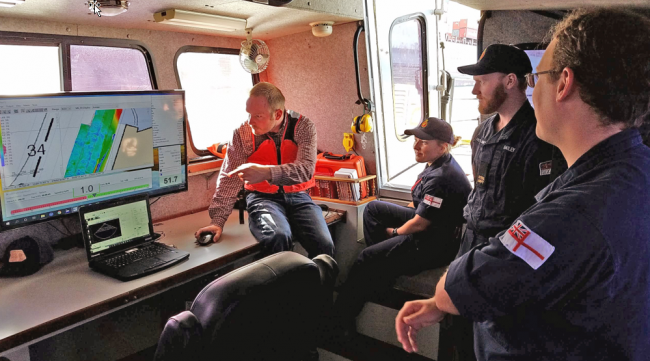
Bob Sherer (aka Bob423), a contributing editor to Waterway Guide Media, met with Matt Foss, Chief of Survey for the Charleston District, USACE on April 26, 2022, to discuss the methodologies and procedures used by USACE in acquiring data and how it is managed and distributed. Using his social media channels, Bob queried members of his ICW Cruising Guide Facebook page to submit questions that are included in the interview. Bob has also been instrumental in working with USACE and Aqua Map Master mobile navigation app to arrive at solutions for displaying surveys as overlays on the app’s charts.
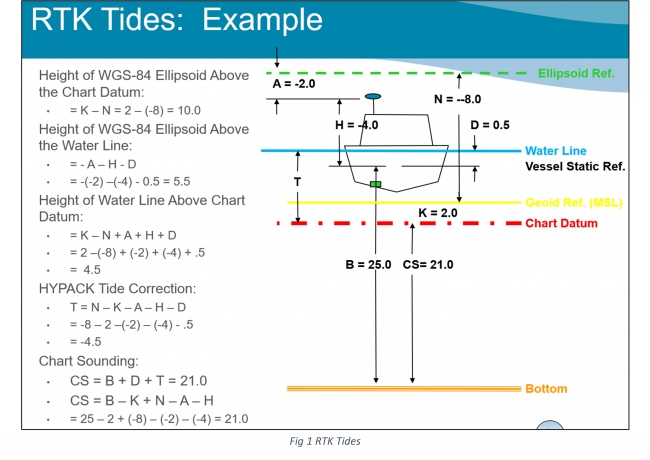
Q1: What does a USACE survey vessel measure? The answer to this is rather complicated. Surprisingly, what they don’t measure is water depth. Obviously, the survey vessel floats in the waters of the ICW but with sophisticated instruments, they measure the distance from the calculated Mean Lower Low Water (MLLW) for points in the survey to the channel bottom.
For the calculations, we use Real-Time Kinematic (RTK) GPS to get a very accurate position in XY and Z. A Geoid model is used to correct that to NAVD88 then an orthometric height correction (distance between NAVD88 and MLLW) or VDatum to correct from NAVD88 to MLLW, or whatever tidal datum we are using. Effectively, we create a moving tide gauge on the vessel so measurements are unaffected by wind-driven tides or high water due to storm events.
After all the calculations, we wind up with the distance from the red line (Chart Datum) to the orange line (Channel Bottom) which is the number displayed on a survey as shown in Fig 1. Such a calculation can be done only if you have an extremely accurate GPS not only in XY but also in Z (height). Our GPS readings are corrected in real-time from a sensor network on land to an accuracy that would fit inside a golf ball.
Q2: Please describe the equipment used to do your surveys? We use an Applanix POSMV INS (Inertial Navigation System) for positioning and attitude to correct for the motion of the vessel. In addition, to get precise positioning (to the size of a golf ball) requires a subscription to a real-time GPS correction network. We use survey-grade single-beam echosounders on the ICW with a beamwidth of 3 degrees and typically make four runs through a survey area channel. For deeper water surveys such as for deep draft harbors, we use multibeam echosounders that provide 100% coverage of the seafloor. Hypack software is used for all of our data collecting and processing. In the screenshot of the survey in Watts Cut in Fig 2, you can see the four survey runs: one along each edge and two in the middle.

Q3: What are the factors considered in choosing which areas to dredge each year? In the Charleston District, we do yearly surveys for the ICW and four times a year for harbors. The selection criteria are based on commercial need, tonnage, etc. Harbors have priority. We also have to maintain the dredge material management sites which require yearly funds, all of which have to fit within our budget. Apart from that, we respond to natural events such as a hurricane or rapid shoaling.
Q4: Is there a webpage or other mechanism to report depth discrepancies akin to NOAA chart errors or USCG ATON discrepancies? There is no webpage or formal mechanism at this time. We do accept input from trusted sources such as commercial captains and Waterway Guide’s Bob423.
Q5: Can USACE surveys through shallow areas always be made to the full width of the cut? Resource restrictions do not allow a routine expansion of the widths of surveys. However, it may be possible to expand the survey width at specific spots. I’ve asked Bob423 to propose a list of such short areas and we will assess if we can do it. It’s not a commitment, but we will try as this would increase navigational safety between dredging events.
Q6: Is there a plan to address the decreasing bridge clearance we’ve seen over the past 10 years? The USACE does not address bridge clearances, that’s the Coast Guard.
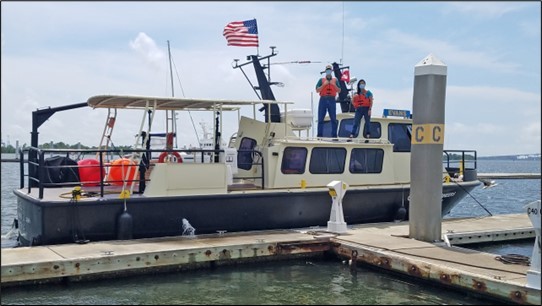
EVANS survey vessel
Q7: Are there any plans to put water level measurement stations at bridges so the clearances can be determined based on current water levels? There are no plans to install water level gauges at bridges on the ICW. The one in Socastee is there because it’s part of the river flood gauge.
Q8: How can recreational boaters be of the most help to USACE? I have thought about it and the best answer I can give you is to keep up doing what you are doing. Your site (ICW Cruising Guide Facebook page and Waterway Guide) and others that have offshoots for specific issues have brought together thousands of people with similar interests and goals. Some of the issues I have seen you all tackle such as anchoring laws, bringing attention to derelict vessels, and navigation issues to the USCG and USACE could never have been done without the support of folks who care about these issues and are willing to make a difference. You all provide a lot of economic benefits to the waterway so make sure your voices are heard.


- 4,000 Marinas
- Thousands of anchorages
- Updated Charts
- Mile-by-Mile Navigation
- Highlighted Alerts & Cautions
- Full-Color Aerial Photographs
The Waterway Guide App Makes it easy to leave reviews, use our explorer, and view waterway guide materials all on the go!